[vc_row][vc_column][vc_row_inner][vc_column_inner][vc_custom_heading text=”Our History of the Liberation Struggle” font_container=”tag:h2|font_size:36px|text_align:left|color:%23df0023″ google_fonts=”font_family:Roboto%3A100%2C100italic%2C300%2C300italic%2Cregular%2Citalic%2C500%2C500italic%2C700%2C700italic%2C900%2C900italic|font_style:700%20bold%20regular%3A700%3Anormal”][vc_separator color=”custom” align=”align_left” border_width=”5″ el_width=”10″ accent_color=”#e99308″ css=”.vc_custom_1717563293714{margin-top: -20px !important;}”][vc_custom_heading text=”1961-1991″ font_container=”tag:h2|font_size:32px|text_align:left|color:%230f9ed5″ google_fonts=”font_family:Roboto%3A100%2C100italic%2C300%2C300italic%2Cregular%2Citalic%2C500%2C500italic%2C700%2C700italic%2C900%2C900italic|font_style:500%20bold%20regular%3A500%3Anormal”][vc_column_text]The most dramatic and self-sacrificing epoch in all of Eritrea’s long and glorious history was the bloody War of Liberation, which concluded with its emancipation into statehood in 1991. For 30 long years, the nation’s heroes steadfastly carried the struggle for freedom forward against all odds. Today when you tour the battlefields where the fallen were martyred, the agony of those years and the ecstasy of the final triumph still hang in the air along with the echoes of heroism that went beyond the call of duty.

The bloodshed began only after continuous, multiple pleas and protests fell on deaf ears. All Eritrean voices were muzzled. So, in search of the collective dream of self-determination and self-development, an armed struggle for liberation was declared as the sole means to achieve independence from Ethiopian rule. On September 1, 1961, a group of independence fighters fired the first shots of the revolution.

The long and bitter, 30-year struggle was against an opponent with a larger population, bigger and better armaments, more resources, and large-scale foreign intervention and investment. On the journey to independence, independence fighters had to also overcome challenges that nature itself presented: rough terrain and weather that made fighting more difficult and famines that led to starvation. Yet against all odds, Eritreans were victorious in realizing their vision of independence.[/vc_column_text][vc_single_image image=”1802″ img_size=”full” alignment=”center”][vc_column_text]The Eritrean people fought a long and difficult struggle for over 30 years to secure their independence from Ethiopian rule. The Eritrean War of Independence began in 1961 when Eritrean nationalists formed the Eritrean Liberation Front (ELF) to resist Ethiopian annexation and to demand self-determination for Eritrea. The conflict escalated over the years, with various factions and groups joining the struggle for independence.

The fighting was marked by significant military campaigns, guerrilla warfare, and diplomatic efforts to gain international support for the Eritrean cause. The Eritrean people endured immense hardships, including displacement, loss of life, and economic deprivation, as they fought for their right to self-determination.

After decades of struggle and sacrifice, Eritrea finally achieved independence on May 24, 1991, following the defeat of Ethiopian forces by the Eritrean People’s Liberation Front (EPLF) in a decisive military offensive. Eritrea was officially recognized as an independent nation, ending years of colonial and annexationist rule.

The struggle for independence remains a significant part of Eritrea’s national identity, symbolizing the resilience, courage, and determination of the Eritrean people in the face of adversity.[/vc_column_text][vc_single_image image=”1804″ img_size=”full” alignment=”center”][/vc_column_inner][/vc_row_inner][/vc_column][/vc_row][vc_row][vc_column][vc_row_inner][vc_column_inner][vc_custom_heading text=”UN Forced Federation and Ethiopian Annexation” font_container=”tag:h2|font_size:36px|text_align:left|color:%23df0023″ google_fonts=”font_family:Roboto%3A100%2C100italic%2C300%2C300italic%2Cregular%2Citalic%2C500%2C500italic%2C700%2C700italic%2C900%2C900italic|font_style:700%20bold%20regular%3A700%3Anormal”][vc_separator color=”custom” align=”align_left” border_width=”5″ el_width=”10″ accent_color=”#e99308″ css=”.vc_custom_1717563293714{margin-top: -20px !important;}”][vc_custom_heading text=”1952-1962″ font_container=”tag:h2|font_size:32px|text_align:left|color:%230f9ed5″ google_fonts=”font_family:Roboto%3A100%2C100italic%2C300%2C300italic%2Cregular%2Citalic%2C500%2C500italic%2C700%2C700italic%2C900%2C900italic|font_style:500%20bold%20regular%3A500%3Anormal”][vc_column_text]During the fourth session of the United Nations General Assembly in September 1949, Western powers resolved that the former Italian colonies of Libya and Somalia would be given their independence after a ten-year Italian trusteeship. On the question of Eritrea, because of opposition to the desire of the Western powers to partition Eritrea between Sudan and Ethiopia, a UN commission was created to research the wishes of the people of Eritrea.

Although it was determined that the majority of the Eritrean people wanted complete independence, the UN Commission of Inquiry presented opposing proposals—independence or unity with Ethiopia—and the UN General Assembly forced Eritrea to accept federation with Ethiopia. Under the guise of reconciling Ethiopian claims of sovereignty and Eritrean aspirations for independence, the Federation provided the path for the United States to secure a military base in Asmara. In December 1950, the United Nations resolved to forcibly join Eritrea to Ethiopia within two years despite the wishes of the Eritrean people for an independent nation.

After years of continuous violations of the Federation terms, in November 1962, Ethiopia’s emperor dissolved the Federation and annexed Eritrea, triggering the 30-year armed struggle in Eritrea.[/vc_column_text][/vc_column_inner][/vc_row_inner][vc_row_inner][vc_column_inner][vc_custom_heading text=”British Colonization” font_container=”tag:h2|font_size:36px|text_align:left|color:%23df0023″ google_fonts=”font_family:Roboto%3A100%2C100italic%2C300%2C300italic%2Cregular%2Citalic%2C500%2C500italic%2C700%2C700italic%2C900%2C900italic|font_style:700%20bold%20regular%3A700%3Anormal”][vc_separator color=”custom” align=”align_left” border_width=”5″ el_width=”10″ accent_color=”#e99308″ css=”.vc_custom_1717563293714{margin-top: -20px !important;}”][vc_custom_heading text=”1941-1951″ font_container=”tag:h2|font_size:32px|text_align:left|color:%230f9ed5″ google_fonts=”font_family:Roboto%3A100%2C100italic%2C300%2C300italic%2Cregular%2Citalic%2C500%2C500italic%2C700%2C700italic%2C900%2C900italic|font_style:500%20bold%20regular%3A500%3Anormal”][vc_column_text]In early 1941, the British defeated the Italians in Eritrea at the Battle of Keren, defining yet another transitional time for Eritrea. On April 1, 1941, British forces seized Asmara and hence placed the colony under British military administration during World War II until the Allied forces would determine its fate. The occupation was intended to be temporary, and the ‘caretaker’ policy was to keep Eritrea weak and disunited in order to maintain control. British forces moved Eritrean industries from Asmara and Massawa to Kenya as war compensation. They destroyed other factories and machinery. They dismantled and removed parts of the Eritrean railway. And immediately following the end of World War II, the British proposed that Eritrea be divided along religious lines and parcelled off between Ethiopia and Sudan, breaking their initial promise of self-governance to the people of Eritrea.[/vc_column_text][/vc_column_inner][/vc_row_inner][vc_row_inner][vc_column_inner][vc_custom_heading text=”Italian Colonization” font_container=”tag:h2|font_size:36px|text_align:left|color:%23df0023″ google_fonts=”font_family:Roboto%3A100%2C100italic%2C300%2C300italic%2Cregular%2Citalic%2C500%2C500italic%2C700%2C700italic%2C900%2C900italic|font_style:700%20bold%20regular%3A700%3Anormal”][vc_separator color=”custom” align=”align_left” border_width=”5″ el_width=”10″ accent_color=”#e99308″ css=”.vc_custom_1717563293714{margin-top: -20px !important;}”][vc_custom_heading text=”1889 – 1941″ font_container=”tag:h2|font_size:32px|text_align:left|color:%230f9ed5″ google_fonts=”font_family:Roboto%3A100%2C100italic%2C300%2C300italic%2Cregular%2Citalic%2C500%2C500italic%2C700%2C700italic%2C900%2C900italic|font_style:500%20bold%20regular%3A500%3Anormal”][vc_column_text]Eritrea was officially declared an Italian colony on January 1, 1890, by the royal decree of Umberto I. Italy’s presence in Eritrea started when an Italian monk purchased land in Assab on behalf of an Italian shipping company in 1869. That land and more that was purchased by the shipping company was then sold to the Italian government in 1882.

With Italy’s conquest of Massawa in February 1885, it quickly consolidated its footing on the Eritrean coastline and areas farther inland. Italy continued with its plan to create a settler colony and faced various forms of protest and resistance. Italy confronted these challenges militarily, politically, and diplomatically. Eventually, Italy steered the process to the delineation of borders between Eritrea and Ethiopia in 1889, resulting in the colonization of Eritrea.[/vc_column_text][/vc_column_inner][/vc_row_inner][vc_row_inner][vc_column_inner][vc_custom_heading text=”Pre-colonial Eritrea” font_container=”tag:h2|font_size:36px|text_align:left|color:%23df0023″ google_fonts=”font_family:Roboto%3A100%2C100italic%2C300%2C300italic%2Cregular%2Citalic%2C500%2C500italic%2C700%2C700italic%2C900%2C900italic|font_style:700%20bold%20regular%3A700%3Anormal”][vc_separator color=”custom” align=”align_left” border_width=”5″ el_width=”10″ accent_color=”#e99308″ css=”.vc_custom_1717563293714{margin-top: -20px !important;}”][vc_custom_heading text=”Pre – 1889″ font_container=”tag:h2|font_size:32px|text_align:left|color:%230f9ed5″ google_fonts=”font_family:Roboto%3A100%2C100italic%2C300%2C300italic%2Cregular%2Citalic%2C500%2C500italic%2C700%2C700italic%2C900%2C900italic|font_style:500%20bold%20regular%3A500%3Anormal”][vc_column_text]The history of Eritrea, dating as far back as 6000 BC, is rich and filled with complexity. The origin of the name Eritrea is the word erythrean, Greek for “red” (in reference to the Red Sea).

In about 338 AD, Christianity was introduced in Eritrea. And the year 615 brought Islam to Eritrea. The strategic location it inhabits has not only been a source of enrichment but also the root of many of its tribulations. Eritrea’s geographical location made it a vital trading route, even during the first millennium BC. Qohaito, found on one of the plateaus of Eritrea, was just one of the thriving ancient trading cities. For centuries, many Eritrean and foreign rulers and empires struggled for control of this region in order to exert power and influence over the trading route, ultimately leading to the establishment of Italian Eritrea in 1890.[/vc_column_text][vc_custom_heading text=”Eritrea” font_container=”tag:h2|font_size:32px|text_align:left|color:%230f9ed5″ google_fonts=”font_family:Roboto%3A100%2C100italic%2C300%2C300italic%2Cregular%2Citalic%2C500%2C500italic%2C700%2C700italic%2C900%2C900italic|font_style:500%20bold%20regular%3A500%3Anormal”][vc_column_text]The State of Eritrea is an African country on the Red Sea coast in the Horn of Africa region of Eastern Africa, with its capital and largest city Asmara landscapes from its 630-mile Red Sea coastline to its high craggy mountains to the desolate Danakil Depression. The capital of Asmara, at 7,600 feet above sea level, is located on a high plateau in the center of the country. The descent from Asmara to the port of Massawa is one of the most spectacular drives in the world, taking nearly three hours over hairpin curves to cover the 65 miles to the coast. On the coast there are some 350 islands. Eritrea was called Mdree-Bahree (which means Land of the Sea) by the local people. The term “Eritrea” derives from the Greek term Sinus Erythraeus, which can be translated in English as Red Sea. Eritrea shares borders with Ethiopia, Sudan and Djibouti. The current population of Eritrea is 6,274,796 (2023 est.). Eritrea population is equivalent to 0.05 percent of the total world population. Eritrea ranks number 111 in the list of countries by population. The land has a total area of 117,600 km² and a total coastline of 2,234 km. Eritrea is thus the 22nd smallest country in Africa and ranked 101st in the world.

After independence from Italian colonial control in 1941 and 10 years of British administrative control, the UN established Eritrea as an autonomous region within the Ethiopian federation in 1952. Ethiopia’s full annexation of Eritrea as a province 10 years later sparked a violent 30-year conflict for independence that ended in 1991 with Eritrean fighters defeating government forces. Eritreans overwhelmingly approved independence in a 1993 referendum.

The country’s lowest point is minus 75 meters, near Dalul in the Danakil Depression; its highest is Mount Soira at 3,018 meters. Only about 12% of the land is arable.[/vc_column_text][vc_single_image image=”1806″ img_size=”full” alignment=”center”][vc_custom_heading text=”Geography Location” font_container=”tag:h2|font_size:32px|text_align:left|color:%230f9ed5″ google_fonts=”font_family:Roboto%3A100%2C100italic%2C300%2C300italic%2Cregular%2Citalic%2C500%2C500italic%2C700%2C700italic%2C900%2C900italic|font_style:500%20bold%20regular%3A500%3Anormal”][vc_column_text]Eastern Africa, bordering the Red Sea, between Djibouti and Sudan

Eritrea’s strategic geopolitical position along the Red Sea is indeed significant. Its retention of the entire coastline since gaining independence in 1993 grants the country control and access to a crucial maritime passage.

Area
total: 117,600 sq km
land: 101,000 sq km
water: 16,600 sq km
comparison ranking: total 101
Land boundaries
total: 1,840 km
border countries (3): Djibouti 125 km; Ethiopia 1,033 km; Sudan 682 km
Coastline
2,234 km (mainland on Red Sea 1,151 km, islands in Red Sea 1,083 km)
[/vc_column_text][vc_single_image image=”1808″ img_size=”full” alignment=”center”][vc_custom_heading text=”Referendum Vote” font_container=”tag:h2|font_size:32px|text_align:left|color:%230f9ed5″ google_fonts=”font_family:Roboto%3A100%2C100italic%2C300%2C300italic%2Cregular%2Citalic%2C500%2C500italic%2C700%2C700italic%2C900%2C900italic|font_style:500%20bold%20regular%3A500%3Anormal”][vc_column_text]In 1993, the Eritrean people voted in a referendum to decide on the future status of their country. The referendum was held from April 23 to April 25, 1993.

The referendum was conducted in accordance with international standards, and Eritreans both inside the country and abroad were eligible to vote. The referendum process was observed by international monitors to ensure fairness and transparency.

The overwhelming majority of Eritreans voted in favour of independence, with over 99.8% of voters choosing to establish Eritrea as a sovereign and independent nation.

The successful outcome of the referendum marked a historic moment for Eritrea, affirming the will of the Eritrean people to determine their own destiny and to establish a new era of self-governance and national identity. Eritrea formally declared independence on May 24, 1993, following the referendum, and the country has since worked to build and develop as an independent nation.[/vc_column_text][vc_single_image image=”1810″ img_size=”full” alignment=”center”][vc_single_image image=”1811″ img_size=”full” alignment=”center”][/vc_column_inner][/vc_row_inner][vc_row_inner][vc_column_inner width=”1/2″][vc_custom_heading text=”Eritrea Currency” font_container=”tag:h2|font_size:32px|text_align:left|color:%230f9ed5″ google_fonts=”font_family:Roboto%3A100%2C100italic%2C300%2C300italic%2Cregular%2Citalic%2C500%2C500italic%2C700%2C700italic%2C900%2C900italic|font_style:500%20bold%20regular%3A500%3Anormal”][vc_column_text]The currency used in Eritrea is the Eritrean nakfa (ERN). The currency is named after the town of Nakfa, which holds historical significance in Eritrea’s struggle for independence.

The nakfa is issued by the Bank of Eritrea, and it’s subdivided into 100 cents. Banknotes and coins are used for transactions, with denominations including 1, 5, 10, 20, 50, and 100 nakfa notes, as well as various coin denominations.

The currency plays a crucial role in the country’s economy, facilitating day-to-day transactions and being utilized for trade and commerce within Eritrea. [/vc_column_text][/vc_column_inner][vc_column_inner width=”1/2″][vc_single_image image=”1813″ img_size=”full” alignment=”center”][/vc_column_inner][/vc_row_inner][/vc_column][/vc_row][vc_row][vc_column][vc_row_inner][vc_column_inner][vc_custom_heading text=”Population distribution” font_container=”tag:h2|font_size:32px|text_align:left|color:%230f9ed5″ google_fonts=”font_family:Roboto%3A100%2C100italic%2C300%2C300italic%2Cregular%2Citalic%2C500%2C500italic%2C700%2C700italic%2C900%2C900italic|font_style:500%20bold%20regular%3A500%3Anormal”][vc_column_text]The population density being highest in central areas around Asmara (the capital) and Keren aligns with the urbanization and concentration of economic activities in these regions. Asmara, specifically, is not only the political and administrative center but also a cultural and economic hub, attracting a significant portion of the population.

The population tends to concentrate in these areas due to various factors such as economic opportunities, better infrastructure, access to services, and historical development. Urban centers often offer better prospects in terms of education, healthcare, and employment, which draws people from surrounding regions.

The distribution of smaller settlements in the north and south could be due to factors like agricultural activities, historical settlements, or natural resources. These areas might have smaller but significant communities engaged in various livelihoods, contributing to the overall socio-economic fabric of Eritrea.

People and Society Population 6,274,796 (2023 est.) comparison ranking: 111 [/vc_column_text][/vc_column_inner][/vc_row_inner][vc_row_inner][vc_column_inner][vc_custom_heading text=”Asmara Capital City” font_container=”tag:h2|font_size:32px|text_align:left|color:%230f9ed5″ google_fonts=”font_family:Roboto%3A100%2C100italic%2C300%2C300italic%2Cregular%2Citalic%2C500%2C500italic%2C700%2C700italic%2C900%2C900italic|font_style:500%20bold%20regular%3A500%3Anormal”][vc_column_text]Asmara, the Eritrean capital, solely as an Italian built colonial city, its origins reach back some 700 years. Originally, it is said, there were four clans living in the Asmara area on the Kebessa Plateau: the Gheza Gurtom, the Gheza Shelele, the Gheza Serenser and Gheza Asmae. Encouraged by their women, the men united the four clans and defeated the bandits who preyed on the area. After the victory, a new name was given to the place, Arbaete Asmara which literally means, in the Tigrinya language, “the four are united.” Eventually Arbaete was dropped and it has been called Asmara, though there is still a zone called Arbaete Asmara.

Asmara was made the capital city of colonial Eritrea in preference to Massawa by Governor Martini in 1897. The city therefore bears many traces of the Italian colonial area: in its infrastructure, its architecture and some culinary traditions. Asmara is by far the largest city in Eritrea, with a population of some 800,000. Asmara sits atop (2,350m) the Eritrean highlands on the eastern edge of the escarpment.

Unlike many of the other towns in Eritrea it is relatively undamaged, the Ethiopian forces having fled the city without fighting a full-scale battle at the end of the war. Under thirty years of Ethiopian occupation, the city was allowed to deteriorate, but it still retains its essential beauty and since coming under Eritrean control in 1991 it has been undergoing a rapid improvement in infrastructure, building repairs and repainting.

The day begins early in Asmara with the first call to prayer of the muezzin from the tower of Asmara ’s main mosque. Not long afterwards the massive bells of the Catholic Cathedral chime the beginning of the Christian day while the Orthodox Church celebrates its early morning mass.

Asmara is possibly the safest African capital for travelers. It is one of the cleanest cities in Africa. The streets are elegantly lined with palms and a string of boutiques, coffee-shops and restaurants reminiscent of southern Italy.[/vc_column_text][/vc_column_inner][/vc_row_inner][vc_row_inner][vc_column_inner width=”1/2″][vc_single_image image=”1816″ img_size=”full” alignment=”center”][/vc_column_inner][vc_column_inner width=”1/2″][vc_single_image image=”1817″ img_size=”full” alignment=”center”][/vc_column_inner][/vc_row_inner][vc_row_inner][vc_column_inner][vc_custom_heading text=”Eritrea’s Administrative divisions” font_container=”tag:h2|font_size:32px|text_align:left|color:%230f9ed5″ google_fonts=”font_family:Roboto%3A100%2C100italic%2C300%2C300italic%2Cregular%2Citalic%2C500%2C500italic%2C700%2C700italic%2C900%2C900italic|font_style:500%20bold%20regular%3A500%3Anormal”][vc_column_text]6 regions (zobatat, singular – zoba); ‘Anseba, Debub (South), Debubawi K’eyyih Bahri (Southern Red Sea), Gash-Barka, Makel (Central), Semienawi K’eyyih Bahri (Northern Red Sea)

Eritrea cities:
• smara (Asmera)
• Agordat (Akordat)
• Assab (Asseb)
• Barentu
• Dahlak islands
• Dekemhare (Decemhare)
• Ghinda (Ginda)
• Keren (Cheren)
• Massawa (Massauwa)
• Mendefera (Adi Ugri)
• Nakfa (Nacfa)
• Semenawi Bahri (Filfil)
• Tessenei (Teseney)
[/vc_column_text][/vc_column_inner][/vc_row_inner][vc_row_inner][vc_column_inner width=”1/2″][vc_column_text]The flag of Eritrea (Tigrinya: ሃገራዊት ባንዴራ ኤርትራ, Arabic: علم إريتريا الوطني) is the national flag of Eritrea. It was adopted on 5 December 1995. The flag combines the basic layout and colours from the flag of the Eritrean People’s Liberation Front with an emblem of a wreath and an upright olive-branch derived from the Eritrean flag from 1952 to 1962.

The green colour in the flag stands for the agriculture and livestock of the country, while the blue represents the bounty of the sea. The red stands for the bloodshed in the struggle for Eritrean independence, with the 30 leaves in the wreath representing the thirty years spent in the struggle for independence.[/vc_column_text][/vc_column_inner][vc_column_inner width=”1/2″][vc_single_image image=”1820″ img_size=”full” alignment=”center”][/vc_column_inner][/vc_row_inner][vc_row_inner][vc_column_inner width=”1/2″][vc_column_text]Nationality noun: Eritrean(s)
adjective: Eritrean
• Ethnic groups
• Tigrinya 50%, Tigre 30%, Saho 4%, Afar 4%, Kunama 4%, Bilen 3%, Hedareb/Beja 2%, Nara 2%, Rashaida 1% (2021 est.
[/vc_column_text][/vc_column_inner][vc_column_inner width=”1/2″][vc_single_image image=”1821″ img_size=”full” alignment=”center”][/vc_column_inner][/vc_row_inner][vc_row_inner][vc_column_inner][vc_custom_heading text=”Eritrea is known for its diverse ethnic landscape, comprising nine officially recognized ethnic groups.” font_container=”tag:h2|font_size:36px|text_align:left|color:%23df0023″ google_fonts=”font_family:Roboto%3A100%2C100italic%2C300%2C300italic%2Cregular%2Citalic%2C500%2C500italic%2C700%2C700italic%2C900%2C900italic|font_style:500%20bold%20regular%3A500%3Anormal”][vc_custom_heading text=”Culture of Eritrea” font_container=”tag:h2|font_size:32px|text_align:left|color:%230f9ed5″ google_fonts=”font_family:Roboto%3A100%2C100italic%2C300%2C300italic%2Cregular%2Citalic%2C500%2C500italic%2C700%2C700italic%2C900%2C900italic|font_style:500%20bold%20regular%3A500%3Anormal”][vc_column_text]The culture of Eritrea is the collective cultural heritage of the various populations native to Eritrea. Eritrea has nine recognized ethnic groups. Each group has their own unique traditions and customs, but some traditions are shared and appreciated among different ethnic groups. The local culture consists of various, and often quite similar, traditions practiced by the nation’s many Cushitic speaking Afro-Asiatic ethnic groups, in addition to those practiced by the area’s Nilotic minorities. Eritrean culture is in some ways similar to the cultures of other countries in the region. [/vc_column_text][vc_column_text]

The Eritrea’s cultural identity is a testament to the unity in diversity of its people, who have coexisted for centuries, sharing and preserving their collective heritage while celebrating their individual traditions. This cultural richness is a source of pride and strength for the nation.[/vc_column_text][/vc_column_inner][/vc_row_inner][/vc_column][/vc_row][vc_row][vc_column][vc_row_inner][vc_column_inner][vc_custom_heading text=”Tourism” font_container=”tag:h2|font_size:32px|text_align:left|color:%230f9ed5″ google_fonts=”font_family:Roboto%3A100%2C100italic%2C300%2C300italic%2Cregular%2Citalic%2C500%2C500italic%2C700%2C700italic%2C900%2C900italic|font_style:500%20bold%20regular%3A500%3Anormal”][vc_column_text]Ideally situated at one of the world’s great crossroads, Eritrea has vast opportunities as a tourist destination. The country’s 1200km (750 miles) coastline along the Red Sea with glorious, deserted contrasting bays and pristine sandy beaches between two deep seaports holds great potential and opportunities for tourism. Eritrea’s crystal-clear, pollution-free coastal waters are adorned by myriad small islands, historical and archaeological sites that are rich and intact, and spectacular coral reefs and abundant marine life that makes the development of facilities for tourist recreation opportune. Furthermore, in the area of water-based tourism much is needed to attract high end tourists with scuba diving and snorkeling ventures in the all-embracing coral reefs of the Red Sea islands. The existence of diverse ethnic groups and cultural, historical, and archaeological sites are also a rich asset for Eritrea as a tourist attraction center.

[/vc_column_text][vc_single_image image=”1824″ img_size=”full” alignment=”center”][vc_single_image image=”1825″ img_size=”full” alignment=”center”][vc_single_image image=”1826″ img_size=”full” alignment=”center”][/vc_column_inner][/vc_row_inner][/vc_column][/vc_row][vc_row][vc_column][vc_row_inner][vc_column_inner][vc_custom_heading text=”Historical Places” font_container=”tag:h2|font_size:32px|text_align:left|color:%230f9ed5″ google_fonts=”font_family:Roboto%3A100%2C100italic%2C300%2C300italic%2Cregular%2Citalic%2C500%2C500italic%2C700%2C700italic%2C900%2C900italic|font_style:500%20bold%20regular%3A500%3Anormal”][vc_custom_heading text=”Eritrea Diverse, Culture, believes rich History” font_container=”tag:h2|font_size:32px|text_align:left|color:%230f9ed5″ google_fonts=”font_family:Roboto%3A100%2C100italic%2C300%2C300italic%2Cregular%2Citalic%2C500%2C500italic%2C700%2C700italic%2C900%2C900italic|font_style:500%20bold%20regular%3A500%3Anormal”][vc_column_text]

[/vc_column_text][/vc_column_inner][/vc_row_inner][vc_row_inner][vc_column_inner width=”1/2″][vc_single_image image=”1829″ img_size=”full” alignment=”center”][/vc_column_inner][vc_column_inner width=”1/2″][vc_single_image image=”1828″ img_size=”full” alignment=”center”][/vc_column_inner][/vc_row_inner][/vc_column][/vc_row][vc_row][vc_column][vc_row_inner][vc_column_inner][vc_custom_heading text=”Mariam Dearit” font_container=”tag:h2|font_size:32px|text_align:left|color:%230f9ed5″ google_fonts=”font_family:Roboto%3A100%2C100italic%2C300%2C300italic%2Cregular%2Citalic%2C500%2C500italic%2C700%2C700italic%2C900%2C900italic|font_style:500%20bold%20regular%3A500%3Anormal”][vc_column_text]Two kilometre out of Keren is the shrine of St. Mariam Dearit, a statue of the Virgin Mary that has its residence inside a trunk of an ancient baobab tree out in the open field, over 500 years old and 75 feet high. The statue is believed to have powers of healing. It is also believed to mark the spot from which fertility springs. Local women brew coffee in the shade of the tree and believe they have been blessed fertility-wise if a passing traveller accepts a cup.
On May 29th every year, there is a pilgrimage to, and a cultural, spiritual and family event at the site. Ten thousand of people from all over Eritrea flock to Keren to enjoy the celebrations and congregate. To attend the prayers, the procession of the statue of the Virgin Mary around the baobab tree and to dance and sing afterwards. [/vc_column_text][/vc_column_inner][/vc_row_inner][vc_row_inner][vc_column_inner width=”1/2″][vc_single_image image=”1831″ img_size=”full” alignment=”center”][/vc_column_inner][vc_column_inner width=”1/2″][vc_single_image image=”1832″ img_size=”full” alignment=”center”][/vc_column_inner][/vc_row_inner][/vc_column][/vc_row][vc_row][vc_column][vc_row_inner][vc_column_inner][vc_custom_heading text=”Eritrea has two main ports along its coastline” font_container=”tag:h2|font_size:32px|text_align:left|color:%230f9ed5″ google_fonts=”font_family:Roboto%3A100%2C100italic%2C300%2C300italic%2Cregular%2Citalic%2C500%2C500italic%2C700%2C700italic%2C900%2C900italic|font_style:500%20bold%20regular%3A500%3Anormal”][vc_column_text]

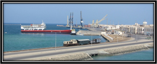
[/vc_column_text][/vc_column_inner][/vc_row_inner][vc_row_inner][vc_column_inner width=”1/2″][vc_single_image image=”1833″ img_size=”full” alignment=”center”][/vc_column_inner][vc_column_inner width=”1/2″][vc_single_image image=”1834″ img_size=”full” alignment=”center”][/vc_column_inner][/vc_row_inner][/vc_column][/vc_row][vc_row][vc_column][vc_row_inner][vc_column_inner width=”1/2″][vc_custom_heading text=”Eritrea National Dates and Holidays” font_container=”tag:h2|font_size:32px|text_align:left|color:%230f9ed5″ google_fonts=”font_family:Roboto%3A100%2C100italic%2C300%2C300italic%2Cregular%2Citalic%2C500%2C500italic%2C700%2C700italic%2C900%2C900italic|font_style:500%20bold%20regular%3A500%3Anormal”][vc_column_text]The Eritrean-Australian Community celebrates several national holidays throughout the year.

    1. Independence Day: Celebrated on May 24th, marking Eritrea’s independence from Ethiopia in 1993.
    2. Martyrs’ Day: Observed on June 20th, honouring those who sacrificed their lives during Eritrea’s struggle for independence.
    3. Fenkil Day: Celebrated on February 08-10th, commemorating the start of the armed struggle for independence in 1975.
    4. 1st of September armed struggle 1961.
    5. March 08 Eritrean Women’s Day or international women’s day as Eritrean one of the parties celebrate.
    6. April 20 Tensae “Easter”
    7. May international day
    8. May 29 festival of Mariam Dearit
    9. July 26-August 03, festival Eritrea Expo
    10. August Eid Al Fitr
    11. September 11 keddus Yohanes “Geez New Year”.
    12. September 27 Meskel finding of the true cross
    13. November 06 Eid Al Adha
    14. December 25 Christmas
    15. New Year’s Day: January 1st.
    16. Orthodox Christian Holidays: Christmas (celebrated on January 7th), Epiphany, Easter.

These holidays often involve various cultural and traditional celebrations, gatherings, and official ceremonies and events across the community. [/vc_column_text][/vc_column_inner][vc_column_inner width=”1/2″][vc_empty_space height=”100px”][vc_single_image image=”1836″ img_size=”full” alignment=”center”][/vc_column_inner][/vc_row_inner][/vc_column][/vc_row][vc_row][vc_column][vc_row_inner][vc_column_inner][vc_custom_heading text=”Eritrean Armed Struggle Landmarks” font_container=”tag:h2|font_size:32px|text_align:left|color:%230f9ed5″ google_fonts=”font_family:Roboto%3A100%2C100italic%2C300%2C300italic%2Cregular%2Citalic%2C500%2C500italic%2C700%2C700italic%2C900%2C900italic|font_style:500%20bold%20regular%3A500%3Anormal”][vc_column_text]1961 September 1 Launching of armed struggle.
1963 October Operation Haikota
1964 March 15 Major ELF offensive against enemy forces
1975 February 1 Large scale offensive against enemy forces around Asmara, Freeing of political prisoners from Adi Quala prison by the ELF.
1976 May 21 Enemy offensive under so-called Raza Project, which involved a peasant force comprising 30-40 men repulsed.
1977 January 7 Liberation of Karora
1977 March 23 Liberation of Nacfa
1977 July 6 Liberation of Dekemhare
1977 July 15 Operation Sembel, Freeing by the EPLF of 800 political prisoners.
1977 September Capture, for the first time, of 100mm T-55 enemy artillery around Ademzemat
1978 July – August Battle of Adi Yakob, Strategic retreat from Northern Front
1978 November Second enemy offensive
1979 January – February Third enemy offensive
1979 April 1 Forth enemy offensive
1979 July 14-26 Fifth enemy offensive
1979 December 2-16 First counter offensive in Nacfa
1982 February 15 – June Sixth enemy offensive (Red Star Campaign) lasting 95 days
1983 March 26 Seventh enemy offensive (Selahta)
1984 January 15 EPLF counter offensive in Tessenei
1984 March 19-21 Demolishing if enemy Wikaw Command, i.e. the enemy’s front in north-eastern Sahel
1984 April 27 Tank battle against enemy forces along Nacfa front
1984 May 21 First commando operation in Sembel, Asmara, in which a total of 33 enemy aircraft, 16 of them MIG fighters were destroyed.
1985 July 6 Liberation of Barentu, strategic retreat from the town after heavy enemy troop reinforcement
1985 October 10 Eight enemy offensive (Bahri Negash)
1988 March 17-19 Demolishing of Naddow IZ and liberation of Afabet
1989 February 17 Joint operation of EPLF Commandoes and Afar Liberation Front revolutionary in Dubti along the Assab-Addis Ababa Road
1990 February 10 Operation Fenkil, liberation of Massawa
1991 May 19-21 Demolishing of enemy front around Dekemhare
1991 May 24 Total liberation of Eritrea
[/vc_column_text][/vc_column_inner][/vc_row_inner][/vc_column][/vc_row]