• Phone: 0470 523 364
  • Email us: info@eacssn.org.au

About Eritrea

Eritrea

Eritrea officially the State of Eritrea, is an African country on the Red Sea coast in the Horn of Africa region of Eastern Africa, with its capital and largest city Asmara landscapes from its 630-mile Red Sea coastline to its high craggy mountains to the desolate Danakil Depression. The capital of Asmara, at 7,600 feet above sea level, is located on a high plateau in the centre of the country. The descent from Asmara to the port of Massawa is one of the most spectacular drives in the world, taking nearly three hours over hairpin curves to cover the 65 miles to the coast. the coast are some 350 islands. Eritrea was called Mdree-Bahree (which means Land of the Sea) by the local people. The term “Eritrea” derives from the Greek term Sinus Erythraeus, which can be translated in English as Red Sea. Eritrea shares borders with Ethiopia, Sudan and Djibouti. The current population of Eritrea is 6,274,796 (2023 est.). Eritrea population is equivalent to 0.05 percent of the total world population. Eritrea ranks number 111 in the list of countries by population. The land has a total area of 117,600 km² and a total coastline of 2,234 km. Eritrea is thus the 22nd smallest country in Africa and ranked 101st in the world.

After independence from Italian colonial control in 1941 and 10 years of British administrative control, the UN established Eritrea as an autonomous region within the Ethiopian federation in 1952. Ethiopia’s full annexation of Eritrea as a province 10 years later sparked a violent 30-year conflict for independence that ended in 1991 with Eritrean fighters defeating government forces. Eritreans overwhelmingly approved independence in a 1993 referendum.

The country’s lowest point is minus 75 meters, near Dalul in the Danakil Depression; its highest is Mount Soira at 3,018 meters. Only about 12% of the land is arable.

Geography Location

Eastern Africa, bordering the Red Sea, between Djibouti and Sudan

Eritrea’s strategic geopolitical position along the Red Sea is indeed significant. Its retention of the entire coastline since gaining independence in 1993 grants the country control and access to a crucial maritime passage.

The Red Sea is one of the world’s busiest shipping lanes, connecting Europe to the Indian Ocean and serving as a vital trade route for various countries. Eritrea’s control over its coastline allows it to oversee and potentially benefit from the maritime trade passing through these waters. Additionally, it provides opportunities for port development and trade-related activities that could potentially contribute to the country’s economy and regional influence.

Area
total: 117,600 sq km
land: 101,000 sq km
water: 16,600 sq km
comparison ranking: total 101
Land boundaries
total: 1,840 km
border countries (3): Djibouti 125 km; Ethiopia 1,033 km; Sudan 682 km
Coastline
2,234 km (mainland on Red Sea 1,151 km, islands in Red Sea 1,083 km)

Eritrea Currency:

The currency used in Eritrea is the Eritrean nakfa (ERN). The currency is named after the town of Nakfa, which holds historical significance in Eritrea’s struggle for independence.

The nakfa is issued by the Bank of Eritrea, and it’s subdivided into 100 cents. Banknotes and coins are used for transactions, with denominations including 1, 5, 10, 20, 50, and 100 nakfa notes, as well as various coin denominations.

The currency plays a crucial role in the country’s economy, facilitating day-to-day transactions and being utilized for trade and commerce within Eritrea.

Population distribution

The population density being highest in central areas around Asmara (the capital) and Keren aligns with the urbanization and concentration of economic activities in these regions. Asmara, specifically, is not only the political and administrative centre but also a cultural and economic hub, attracting a significant portion of the population.

The population tends to concentrate in these areas due to various factors such as economic opportunities, better infrastructure, access to services, and historical development. Urban centres often offer better prospects in terms of education, healthcare, and employment, which draws people from surrounding regions.

The distribution of smaller settlements in the north and south could be due to factors like agricultural activities, historical settlements, or natural resources. These areas might have smaller but significant communities engaged in various livelihoods, contributing to the overall socio-economic fabric of Eritrea.

People and Society
Population
6,274,796 (2023 est.)
comparison ranking: 111
Nationality
noun: Eritrean(s)

adjective: Eritrean
Ethnic groups
Tigrinya 50%, Tigre 30%, Saho 4%, Afar 4%, Kunama 4%, Bilen 3%, Hedareb/Beja 2%, Nara 2%, Rashaida 1% (2021 est.

Eritrea is known for its diverse ethnic landscape, comprising nine officially recognized ethnic groups:

  • Afar: Primarily found in the southern part of Eritrea, as well as in parts of Ethiopia and Djibouti. They are traditionally nomadic pastoralists and fishermen.
  • Bilen: Inhabitants of the area around the town of Keren in central Eritrea. They are mainly agriculturalists and traders.
  • Hedareb: Primarily found in the western lowlands of Eritrea, engaged in farming, herding, and trade.
  • Kunama: Reside in the southwestern part of Eritrea near the border with Ethiopia. They are mainly agriculturalists.
  • Nara: Inhabit the area around the town of Agordat in western Eritrea. Their livelihoods involve agriculture and trade.
  • Rashaida: Known for their nomadic lifestyle, they primarily reside in the northern Red Sea region. Historically, they’ve been involved in trade and camel herding.
  • Saho: Mainly found in the southern and central highlands of Eritrea, engaged in agriculture and trade.
  • Tigre: Primarily inhabit the northern and western parts of Eritrea, particularly the coastal areas, and are involved in agriculture and trade.
  • Tigrinya: The largest ethnic group in Eritrea, predominantly residing in the central highlands and parts of the western lowlands. They are engaged in various occupations including farming, trade, and civil services.

Each ethnic group in Eritrea has its own distinct cultural practices, languages, and traditions, contributing to the rich diversity of the country.

note: data represent Eritrea’s nine recognized ethnic groups.

Languages
Tigrinya (official), Arabic (official), English (official), Tigre, Kunama, Afar, other Cushitic languages
Religions
Eritrean Orthodox, Roman Catholic, Evangelical Lutheran, Sunni Muslim

This is the population pyramid for Eritrea. A population pyramid illustrates the age and sex structure of a country’s population and may provide insights about political and social stability, as well as economic development. The population is distributed along the horizontal axis, with males shown on the left and females on the right. The male and female populations are broken down into 5-year age groups represented as horizontal bars along the vertical axis, with the youngest age groups at the bottom and the oldest at the top. The shape of the population pyramid gradually evolves over time based on fertility, mortality, and international migration trends.

population of Eritrea is 6,274,796 (2023 est.)

Education

Eritrea education is considered a fundamental right, and the government has implemented policies to ensure access to free education for all citizens. The National Policy Education Plan in Eritrea emphasizes the importance of providing universal access to education at all levels, from primary school to higher education.

The government of Eritrea is committed to providing free education as part of its efforts to promote human development and social equity. This policy aims to remove barriers to education and ensure that all children have the opportunity to receive quality schooling, regardless of their socio-economic background.

By offering free education, Eritrea aims to achieve several goals, including:

Increased Enrollment: Free education encourages more children to enrol in school, leading to higher attendance rates and improved literacy levels across the country.

Equitable Access: Removing financial barriers ensures that education is accessible to all children, regardless of their family’s income level or economic status.
Promotion of Human Capital: Investing in education helps to build a skilled workforce and promote economic development, as educated individuals contribute to the country’s growth and prosperity.

Social Inclusion: Free education promotes social inclusion by providing equal opportunities for all children to access learning and develop their potential.

Eritrea National Education Sector Plan:

The strategic priority is to improve quality of learning in primary and secondary education by expanding early childhood education, improving teacher qualifications, and by bringing more out-of-school children into schools.

The plan further identifies girls’ education and special needs education as cross cutting areas for action. is responsible for education policy formulation, education sector plans, curriculum development, human capacity development, financial planning, disbursements, and reporting. Its organizational structure is composed of the Minister’s Office, five departments and six regional (Zoba) education offices.

According to the Decentralization Act 1996, the six Zoba Education Offices are responsible for overall administration and management of the education sector in their respective region. The school management office/unit, together with the Parent Teacher Student Associations (PTSAs), are responsible for the overall school management and school development programs.

The sector plan sets as its main strategic priorities to meet the sustainable development goal 4 (SDG 4):

  • the improvement of quality learning,
  • improving access to quality early childhood education and school readiness,
  • equity in view of social justice
  • relevance, access, efficiency and inclusiveness in Basic and Secondary Education with special attention to children with disability, the girl child and children from disadvantaged communities
  • the expansion of adult and non-formal education and the promotion of continued lifelong learning.

The Eritrea Institute of Technology, also known as Mai-Nefhi College, is indeed a prominent educational institution in Eritrea.

Location: The institute is located near the town of Himbrti, specifically in Mai Nefhi, Eritrea. It is approximately 12 kilometers southwest of the capital city, Asmara. The campus is situated near the Mai Nefhi dam, providing a picturesque setting for learning and research.

Colleges: The Eritrea Institute of Technology comprises three colleges, each offering specialized programs:
College of Science: Offers courses and degrees in various scientific disciplines, including mathematics, physics, chemistry, and biology.

College of Engineering and Technology: Provides education and training in engineering fields such as civil engineering, mechanical engineering, electrical engineering, and computer engineering.

College of Education: Focuses on teacher training and education-related programs to prepare future educators for roles in primary and secondary schools.

Curriculum: The institute offers a comprehensive curriculum designed to provide students with theoretical knowledge and practical skills relevant to their chosen fields. The programs are structured to meet international standards and prepare graduates for successful careers or further studies.

Facilities: The Eritrea Institute of Technology is equipped with modern facilities, including classrooms, laboratories, libraries, and workshops. These facilities support hands-on learning, research activities, and collaborative projects among students and faculty members.

Mission: The institute’s mission is to provide high-quality education and training in science, engineering, technology, and education to contribute to the socio-economic development of Eritrea. It aims to produce skilled professionals and educators who can address the country’s evolving needs and challenges. Overall, the Eritrea Institute of Technology plays a crucial role in advancing education and human capital development in Eritrea. Through its diverse colleges and rigorous programs, it helps prepare students for successful careers and leadership roles in various sectors of the economy.

Orotta College of Medicine and Health Sciences

The Orotta College of Medicine and Health Sciences (OCMHS) in Eritrea is a prominent institution dedicated to training healthcare professionals and advancing medical education in the country. Here are some key points about the college:

Location: The Orotta College of Medicine and Health Sciences is located in Asmara, the capital city of Eritrea.

Establishment: The college was established to address the need for skilled healthcare professionals in Eritrea and to improve the country’s healthcare system.

Programs Offered: OCMHS offers a variety of programs in medicine, nursing, pharmacy, laboratory technology, and other allied health fields. These programs are designed to provide students with the knowledge, skills, and practical experience needed to excel in their chosen healthcare professions.

Faculty and Staff: The college boasts a team of experienced faculty members who are experts in their respective fields. These faculty members are dedicated to providing high-quality education and mentorship to students.

Facilities: OCMHS is equipped with modern facilities, including classrooms, laboratories, libraries, and clinical training sites. These facilities support hands-on learning and research activities, allowing students to gain practical experience in real-world healthcare settings.

Accreditation and Recognition: The college is accredited by the Ministry of Education in Eritrea and meets international standards for medical education. Graduates of OCMHS are recognized for their competence and professionalism both nationally and internationally.

Contribution to Healthcare: Orotta College of Medicine and Health Sciences plays a vital role in addressing healthcare challenges in Eritrea by producing qualified healthcare professionals who are equipped to provide quality care to the population.

Overall, OCMHS is a leading institution in Eritrea’s healthcare sector, contributing to the development of a skilled healthcare workforce and the improvement of healthcare services in the country.

Climate in Eritrea

Eritrea experiences diverse climatic conditions across its regions due to variations in altitude and geography. Broadly, the country can be categorized into three main climatic zones: the highlands, lowlands, and coastal areas.

Highlands: The highlands, including places like Asmara and other central regions, have a temperate climate with mild to warm temperatures. Summers (from June to September) are generally mild and pleasant, while winters (from December to February) can be cool and sometimes chilly, especially in higher elevations.

Lowlands: The lowland areas, such as the western and eastern lowlands, experience hotter and drier conditions. These regions have higher temperatures throughout the year, particularly during the summer months, with temperatures often exceeding 40°C (104°F) in some areas.

Coastal Areas: Coastal regions, including cities like Massawa and Assab, have a hot desert climate with high temperatures throughout the year. Summers are extremely hot, and humidity levels can be high along the Red Sea coast. Winters are relatively milder but still warm.

Rainfall patterns vary significantly across these regions. The highlands receive more rainfall compared to the lowlands and coastal areas. The rainy season typically occurs from June to September in the highlands, while the lowlands and coastal regions experience minimal rainfall and are mostly arid or semi-arid.

Eritrea’s climatic diversity allows for various agricultural practices suited to the different regions, while also offering tourists a range of experiences based on their preferences for climate and activities.

Administrative divisions

6 regions (zobatat, singular – zoba); ‘Anseba, Debub (South), Debubawi K’eyyih Bahri (Southern Red Sea), Gash-Barka, Makel (Central), Semienawi K’eyyih Bahri (Northern Red Sea)

    Eritrea cities:

  • smara (Asmera)
  • Agordat (Akordat)
  • Assab (Asseb)
  • Barentu
  • Dahlak islands
  • Dekemhare (Decemhare)
  • Ghinda (Ginda)
  • Keren (Cheren)
  • Massawa (Massauwa)
  • Mendefera (Adi Ugri)
  • Nakfa (Nacfa)
  • Semenawi Bahri (Filfil)
  • Tessenei (Teseney)

Asmara Capital City

Asmara, the Eritrean capital, solely as an Italian built colonial city, its origins reach back some 700 years. Originally, it is said, there were four clans living in the Asmara area on the Kebessa Plateau: the Gheza Gurtom, the Gheza Shelele, the Gheza Serenser and Gheza Asmae. Encouraged by their women, the men united the four clans and defeated the bandits who preyed on the area. After the victory, a new name was given to the place, Arbaete Asmara which literally means, in the Tigrinya language, “the four are united.” Eventually Arbaete was dropped and it has been called Asmara, though there is still a zone called Arbaete Asmara.

Asmara was made the capital city of colonial Eritrea in preference to Massawa by Governor Martini in 1897. The city therefore bears many traces of the Italian colonial area: in its infrastructure, its architecture and some culinary traditions. Asmara is by far the largest city in Eritrea, with a population of some 800,000. Asmara sits atop (2,350m) the Eritrean highlands on the eastern edge of the escarpment.

Unlike many of the other towns in Eritrea it is relatively undamaged, the Ethiopian forces having fled the city without fighting a full-scale battle at the end of the war. Under thirty years of Ethiopian occupation, the city was allowed to deteriorate, but it still retains its essential beauty and since coming under Eritrean control in 1991 it has been undergoing a rapid improvement in infrastructure, building repairs and repainting.

The day begins early in Asmara with the first call to prayer of the muezzin from the tower of Asmara ’s main mosque. Not long afterwards the massive bells of the Catholic Cathedral chime the beginning of the Christian day while the Orthodox Church celebrates its early morning mass.

Asmara is possibly the safest African capital for travelers. It is one of the cleanest cities in Africa. The streets are elegantly lined with palms and a string of boutiques, coffee-shops and restaurants reminiscent of southern Italy.

Asmara: A Modernist African City

Asmara stands as a unique and historically rich city, blending its past influences with a dynamic present. It continues to be a focal point for cultural, economic, and social activities in Eritrea.

Asmara is the capital and largest city of Eritrea, located in the central highlands of the country.

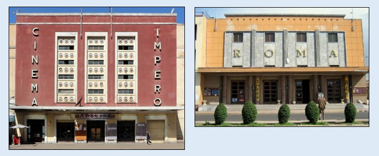
Asmara is situated at an altitude of 2350 meters and has a population of close to 400,000. Originally a commercial centre; Asmara was developed into its present form by the Italians as their administrative centre, becoming the capital city in 1897 filled with Jacaranda and bougainvillea, the city has an almost Mediterranean atmosphere. Asmara is full of Italianate architecture in the art deco style of the 1920s and 1930 s. Broad palm tree lined boulevards cafes; lead through to well tend public gardens; elegant places and imposing churches. Behind this formal exterior lies a lively and traditional city.

The relaxing and welcoming atmosphere is enhanced by the climate: The annual mean temperature is 17° C though even in winter (November to January) the days have clear blue skies and it is warm enough to wear short sleeved shirts. The main rainfall occurs in July and August when humidity can reach 70 percent.

Historical Significance: Asmara has a rich history shaped by various influences, including Italian colonial rule during the late 19th and early 20th centuries. The city’s architecture still reflects this period, with well-preserved examples of Art Deco and Modernist styles.

Keren City

The mountain city Keren is the largest of the five major secondary towns in Eritrea with a population of 120,000 and the regional capital of the Anseba Region and its diversity town.

Keren is a beautiful town and is often visited by those wanting a change of scene from Asmara or Massawa. The name Keren means highland. The sun rises over one set of peaks in the east and sets over another set in the west. Depending on where you stay, rising for the dawn does not present a problem as the muezzin is likely to act as your early morning call.

Keren is one of the major agricultural centres of Eritrea, particularly for fruits and vegetables. To the west the region is known for its banana plantations. In addition, its dairy herds supply fresh milk, butter and the cheese factory produce provolone and other cheeses.

There is a town market, where silver items may be purchased, and a wood market, where camels gather on the dry riverbed. On Mondays there is a livestock market in a walled compound on the hillside along the road leading south from town. Cattle, sheep and goats, camels and donkeys are bought and sold.

Keren hosts many examples of Italian and Ethiopian colonial heritage. Overlooked by a seemingly impregnable Egyptian 19th century fortress (Tigu), which still bristles with Ethiopian army cannon, Keren boasts stylish public buildings and a Romanesque Catholic church. There are good views from the top of the fort (1460m). At its foot lie the ruins of the old Imperial Palace, which were destroyed during the Struggle in 1977.

At one time Keren boasted not one but two railway stations. One of them now serves as the local bus station, both for the buses to Asmara, Nacfa and Barentu and for the yellow Toyota taxi buses that intersect Keren. The speed of life is best exemplified by the fact that camels and donkeys still outnumber cars.

Agordat (Akordat) City

Agordat lies 75 kilometres west from Keren, in the Western Lowlands. Agordat is an old town, formerly the capital of the Barka zone. It is at the western termination of the railway from Massawa. The town can experience high temperatures, and sandstorms known as haboob.

Agordat is located on the river Barka. The Barka River is shallow with wide deposits of sand extending to both sides. The river only floods when the rain is pouring. With the rains the water from the surrounding mountains flows down and the river becomes full.

The area is famous for its banana plantations. The Akat trees or Doum Palms seen along the Barka River are known for their fruit.

Agordat is a bustling market town. The mosque, the second largest in Eritrea was built by Haile Selassie in 1963. He also built the Catholic church and the large hospital which sits on a hill overlooking the town just below the ornate former Italian governor’s palace.

An obelisk overlooking the town is a monument to Italians killed during the Second World War, but apart from the administrative buildings, the old railway station and the Barka Hotel, that’s the only real sign of Europe.

Barentu City

In the dry arid region of the Western Lowlands lies Barentu. With its one main street there are many nomadic tribes in this area and Barentu is in the heart of Kunama territory. It is believed that the Kunama people were among Eritrea’s first inhabitants.

Being a market town Barentu attracts many people from the surrounding areas and there is a colorful mix of tribal cultures. The dusty streets ripple with everyday life. With the heat here in the Western Plains the pace of life is refreshingly slow and marketing is a leisurely chat.

During the Ethiopian invasion that took place in 2000 most of the town was destroyed and plundered.

Best time to visit: Tuesdays or Saturdays when the Kunama people come out of their village to visit the market.

Tessenei City

Tessenei is located 45 kilometres from the Sudanese border and approximately 115 kilometres beyond Barentu. Tessenei is a population center for the western area, a frontier town with about 18,000 people from various ethnic backgrounds. The marketplace buzzes with nomadic traders, Tigrayan merchants and returnees from Sudan. The main square in front of the mosque is abuzz with many kinds of different trade, including tailors, cafés, bars and other shops.

There is a busy exchange market where the Saudi Rial and the Sudanese Pound are exchanged to Eritrean Nakfa’s and the food in the ‘souk’ area has a distinctly Sudanese flavour. Tessenei is one of the reception points for returnees from the refugee camps in the Sudan who then proceed to other locations.

On the outskirts of Tessenei to the north are a couple of hills from which there are exceptional views of the lowlands and the mountains inside Sudan. 10 kilometres to the west of the city is the Barattolo cotton plantation at Adi Ghider where Hedareb tribes and 1500 ex-fighters and their families farm cotton, sesame and sorghum. Adi Ghider is an old Italian frontier village, still containing a few Italian relics, but the village was extensively sacked by the Ethiopian forces in 2001 in their campaign to sabotage the Eritrean economy.

Tessenei itself was liberated in 1988, having suffered extensive damage during the was of liberation (1961 -1991). Outside Tessenei just beyond Haykota, is a monument to Idirs Awate. He fired the first shots in the liberation struggle in September 1961.

During the rainy season (July to September) most areas around Tessenei are impassable, but the recently constructed asphalt road from Barentu to Tessenei guarantees a comfortable trip by road to this border village. Daily buses leave to both Kassala in Sudan, Barentu and Asmara, the Eritrean capital.

Semhar (Ghinda) City

Approximately halfway between Asmara and Massawa lies Ghinda, an interesting village in a little valley that, especially during the first months of the year, is a sharp contrast to the dryness on much of the Asmara plateau, because it traps the prevailing moisture from the coast, resulting in higher rainfall.

The Asmara-Massawa Road turns left into the main street of Ghinda, crossing a river. It was always a Favorite spot for Italian residents not least because the rain and fertile soil made it, and still do make it, a major agricultural area. Its green terraced hillsides supply the fruit and vegetable markets of Asmara and Massawa.

Ghinda is a popular place to stop on the journey between Massawa and Asmara and travellers usually do so for half an hour for a break. Any of the restaurants opposite the bus stop are worth trying for a meal or refreshments.

The town was severely damaged in the war of liberation. the cemetery outside Ghinda contains the bodies of 3500 men and women fighters killed at the Ghinda front in 1990.

Nacfa (Nakfa) City

About 150 kilometer north of Keren lies the capital of the Sahel province, Nacfa. It holds a special significance for Eritreans, being home to the EPLF during the war. For a long time it was the base of EPLF resistance. The Ethiopian Air force bombed the whole town, except the minaret of the Mosque which served as point of orientation for the pilots. As a result, Nacfa was very heavily damaged. After the liberation of Eritrea, the town has been completely rebuilt.

About 150 kilometer north of Keren lies the capital of the Sahel province, Nacfa. It holds a special significance for Eritreans, being home to the EPLF during the war. For a long time it was the base of EPLF resistance. The Ethiopian Air force bombed the whole town, except the minaret of the Mosque which served as point of orientation for the pilots. As a result, Nacfa was very heavily damaged. After the liberation of Eritrea, the town has been completely rebuilt.

Closest to the town, and particularly for those who are interested in the military history, are the trenches of Denden. Here you can find the sites of the liberation struggle: underground offices, hospitals, factories, school and homes, trenches and bunkers. Many of these underground facilities are still accessible.

The climb to the twin peaks of Denden, a mountain that served as the EPLF radio transmission ‘tower’ during the war of liberation is well worth the effort just for the view.

The Eritrean unit of currency, Nakfa, introduced in 1998, is named after this town in the Sahel mountains.

Mendefera City

Mendefera, also known as Adi Ugri, is the capital city of Zoba Debub. It is situated 54 kilometers south of Asmara, and worth a one-day trip. Driving to Mendefera is a pleasant experience where the rolling mountains and hills are covered with acacia and the barren ones are full of colour.

It is easy to climb the various hills in this village to enjoy the views. Situated on two hills opposite one another, on two sides of the main road passing through Mendefera one will find the two most prominent buildings in the town: The St. Georghis Coptic Church and the Catholic Church and School.

The name Mendefera derives from the high hill in the centre of the city and is a source of pride to Eritreans. It means ‘no one dared’ and is a reminder of the fierce resistance put up by the local people to the Italian colonialism.

Mendefera was built during the Italian era. Earlier, the place was a thick jungle, where wild animals roamed making it impossible for anyone to live in. It is now a bustling market town in a fertile region of Eritrea, and a place where small- and large-scale factories produce different products.

Dekemhare (Decemhare) City

Dekemhare, also known as Decemhare, holds a significant historical and cultural importance in Eritrea. Situated approximately 40 kilometers south of the capital city Asmara, Dekemhare was favoured by the Italians for its mild climate and fertile soil. Originally planned as an industrial centre and transportation hub, it played a pivotal role in the agricultural endeavours of the Italian colonial era.

During the Italian occupation, Dekemhare thrived as one of the primary agricultural regions, cultivating grapes for wine production and a variety of other fruits and vegetables. The remnants of this industrial and agricultural legacy can still be seen today, with landmarks such as the Red Sea General Mills, a biscuit factory, and the Dekemhare pasta factory serving as reminders of its past prosperity.

The town’s northern part, inhabited by the native population during colonial times, remains the vibrant heart of Dekemhare. Here, one can find bustling streets lined with shops, boutiques, barbershops, and the old market. The area around the city park, cinema, and administration buildings exudes a nostalgic charm, with former Italian apartment buildings adorned with grapevines, bougainvillea, and jacarandas.
Despite its tranquil setting, Dekemhare has also witnessed significant historical events, particularly during Eritrea’s struggle for independence. In December 1962, it became the site of the first major military actions by Eritrean liberation forces against Ethiopian annexation. Furthermore, Dekemhare was embroiled in skirmishes and offensives during the final battle of the war of liberation, which commenced on May 19th, 1991.

Today, Dekemhare stands as a testament to Eritrea’s rich history and resilience, blending its colonial heritage with the spirit of its people’s struggle for freedom. As a rural town with deep roots in agriculture and industry, it continues to contribute to Eritrea’s cultural tapestry while preserving its historical significance for future generations.

Massawa Port City and port Eritrea

Massawa, also known as Mitsiwa or Massauwa, holds a significant place in Eritrea’s history and culture. Comprising two islands and the mainland, Massawa is connected by causeways, each offering unique attractions and experiences.

The mainland part of Massawa, where the majority of the population resides, is characterized by salt ponds and a bustling urban atmosphere.

However, its main appeal lies in its islands:

  • Taulud Island: This island houses several notable landmarks, including the war memorial, St. Mariam’s Cathedral, the old railway station, the Dahlak Hotel, and the Imperial Palace. Visitors can explore these historical sites and soak in the island’s cultural heritage.
  • Batse: Connected by a causeway, Batse is a charming port area with a Moorish ambiance. Its narrow alleyways, flanked by Turkish, Egyptian, and Italian buildings, come alive at night with bustling bars and restaurants, offering a vibrant nightlife experience.

Despite its historical significance and charm, Massawa suffered extensive damage during past conflicts. However, efforts are underway to rehabilitate and revitalize the city, with the dockyard back in operation and handling a significant volume of merchandise.

Today, Massawa serves as Eritrea’s main port, providing vital access to the rest of the world. It also serves as a departure point for trips to the nearby Dahlak Islands and diving expeditions, offering opportunities for adventure and exploration.

Nature enthusiasts will appreciate the pristine beaches of Gurgusum, located north of Massawa, which offer opportunities for sunbathing, swimming, sailing, scuba diving, and snorkelling in clean and uncrowded surroundings.

For dining options, visitors can explore restaurants such as the Eritrean Restaurant, offering a variety of meals at affordable prices, including pasta, steaks, grilled fish, and salads. Salaam, a modest fish restaurant in the old town area, serves generous portions of grilled fish at reasonable prices, making it a popular choice among locals and tourists alike.

While exploring Massawa and its surroundings, visitors are advised to stay hydrated due to the high temperatures, and it’s essential to always carry a water bottle.

Overall, Massawa offers a rich tapestry of history, culture, and natural beauty, making it a must-visit destination for travellers seeking an authentic Eritrean experience.

Special event / National Holiday 10 February Operation Fenkil Anniversary, a remembrance of the last days of the war fought to liberate the city of Massawa (1990). The three tanks at the end of the first causeway were the main military hardware, used by the EPLF in the operation Fenkil. They now serve as a statue, at the spot where they halted in February 1990, in memory of those who gave their lives for the liberation of Massawa.

Assab City and port of Eritrea

Assab, situated on the coast of Eritrea, holds a significant position as the main port of the country. Its importance dates back to 1869 when it was purchased by the Rubattino Shipping Company on behalf of the Italian government. Assab’s strategic location near the Bab el Mandeb straits made it an attractive choice for the development of a trading station between Ethiopia and Arabia.

Over the years, Assab has evolved into a modern port, featuring facilities such as an oil refinery, which was constructed by the former Soviet Union. Historically, it served as the primary port for Addis Ababa, the capital of Ethiopia, giving it a more Ethiopian than Eritrean atmosphere.

The town of Assab is divided into three distinct parts:
Assab Seghir (Small Assab): Located along the shoreline, this area is likely characterized by residential neighborhoods and smaller commercial establishments.

Assab Kebir (Big Assab): Situated in the center of town, Assab Kebir houses the main port facilities, city center, and likely larger commercial and administrative buildings.

Campo Sudan: Nestled behind Assab Kebir, Campo Sudan is described as rather ramshackle and was formerly the domain of Ethiopian residents. It may retain elements of its historical character.

In addition to its urban areas, Assab is surrounded by extensive salt flats, which may have economic significance for the region. Furthermore, the Bay of Assab is home to approximately 30 islands, offering opportunities for exploration and tourism.

Assab’s history, strategic importance, and economic significance make it a notable destination within Eritrea. While it may have a predominantly Ethiopian influence due to its historical ties, it remains an integral part of Eritrea’s maritime infrastructure and serves as a gateway to the Red Sea for trade and commerce.

Eritrea’s Agriculture:

Agriculture plays a significant role in Eritrea’s economy, employing a large portion of the population and contributing to both subsistence and commercial farming.

The agricultural sector in Eritrea is diverse and varied due to the country’s diverse geography, ranging from highlands to lowlands. The main crops grown include sorghum, millet, wheat, barley, teff, and various pulses. Additionally, fruits like citrus, bananas, and grapes are cultivated in suitable regions. Coffee is also an important cash crop for some farmers.

Livestock farming, including cattle, sheep, goats, camels, and poultry, is an integral part of the agricultural landscape, especially among nomadic and pastoralist communities.

Challenges faced by the agricultural sector in Eritrea include limited access to modern farming technologies, fluctuating rainfall leading to drought conditions, soil erosion, and the need for improved infrastructure and agricultural practices to enhance productivity.

The government has been focusing on agricultural development initiatives, including water conservation projects, soil conservation efforts, and promoting more resilient crop varieties to improve food security and boost the agricultural sector’s contribution to the economy.

Economic and natural resources

Eritrea’s economic focus on the mining sector and its abundant natural resources, particularly in minerals like gold, potash, zinc, copper, salt, possibly oil and natural gas and fish.

Mining Sector Focus: Eritrea’s economy has a notable emphasis on the mining sector, which contributes significantly to the country’s GDP and export earnings.

Abundant Natural Resources: Eritrea is rich in natural resources, with significant deposits of minerals such as gold, copper, zinc, and potentially other minerals that remain untapped.

Key Mining Projects: The Bisha mine, which produces gold, copper, and zinc, is one of the primary contributors to Eritrea’s mining industry. Additionally, there are other mining projects in the country that contribute to economic activity and employment.

Government Support: The government of Eritrea has been proactive in encouraging further investments in the mining sector to harness its potential for economic growth. This includes providing support for exploration, development, and infrastructure projects related to mining activities.

Economic Contribution: Revenue generated from mining activities plays a significant role in Eritrea’s economy, contributing to the country’s GDP and export earnings. The income derived from the mining sector helps support government initiatives and investments in other areas of development.

Eritrea has two main ports along its coastline:

Massawa Port: Located in the northern part of the country on the Red Sea coast, Massawa is one of Eritrea’s principal ports. It has historical significance and serves as a key hub for trade and commerce, handling goods and cargo for import and export.

Assab Port: Situated in the southern part of Eritrea along the Red Sea, Assab Port is another crucial seaport. It historically served as a major outlet for Eritrea’s trade.

Both ports have been important for Eritrea’s economy, facilitating trade activities and serving as essential gateways for the import and export of goods to and from the country.

Eritrea's Build Dams

Eritrea builds 785 Big and Small dams in the past 30 years, has been constructed for various purposes, including irrigation and securing clean water for agricultural and livestock use. Here’s how these efforts contribute to long-term water security:

  • Irrigation: Building dams for irrigation purposes allows Eritrea to harness water resources for agricultural activities. By storing water during rainy seasons and releasing it during dry periods, these dams help farmers maintain consistent water supplies for crop cultivation. This irrigation infrastructure enhances agricultural productivity, supports food security, and reduces reliance on rain-fed agriculture, especially in areas prone to drought.
  • Livestock Watering: Dams also provide water for livestock watering, ensuring that animals have access to clean and reliable water sources. This is crucial for maintaining the health and productivity of livestock, which play a significant role in Eritrea’s agricultural sector, particularly among pastoralist and nomadic communities.
  • Clean Water Supply: In addition to agricultural and livestock use, dams contribute to securing clean water supplies for human consumption and domestic use. By storing and regulating water flow, dams help mitigate the impact of water scarcity and ensure access to safe and reliable drinking water for communities residing in both rural and urban areas.
  • Long-Term Water Security: The construction of dams for irrigation and clean water supply supports long-term water security in Eritrea. By effectively managing water resources, the country can mitigate the effects of climate variability, reduce water-related risks, and enhance resilience to droughts and other water challenges. This contributes to sustainable development and improves the overall well-being of the population.

Overall, Eritrea’s efforts to build dams for irrigation and clean water supply are essential for enhancing agricultural productivity, ensuring access to water for livestock and human consumption, and promoting long-term water security and sustainable development.